|
Saskatchewan The Place |
|
 |
|
| FTLComm - Tisdale - March 21, 2001 | |
|
straight |
I was drawing the chart above to illustrate Saskatchewan it occurred to me that there a number of unique features to Saskatchewan that many people either do not know or have never ever thought about. I distorted the vertical appearance of the image so that I could fit it on a web page but Saskatchewan is the only province in Canada with these geographically apparent straight borders. |
|
|
|
|
long |
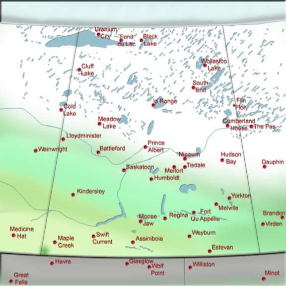
The bottom border of the province is the the 49th parallel of latitude and the Northern boarder is the 60th which make s for a long province and almost all maps show only half the province, from Principe Albert South. This is the inhabited portion of the province and on this chart shown here I have illustrated the Northern portion of the province as it appears right now as covered with snow and ice. |
|
|
|
|
landforms |
The next big and broad feature of the province is that it is actually divided into some distinctive landforms. The odd area Southwest of Maple Creek, called the Cypress hills is actually more than five thousand feet above sea level and actually was not covered in the last ice age. The other anomaly is in the South Eastern portion of the province called the Moose Mountain is actually a very old granite formation under the surface and within that area are oil deposits. |
|
|
|
|
water |
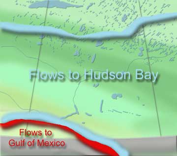 If you draw a line from mid way between Moose Jaw and Assinaboia. From North of Swift Current all water flows ultimately into the Manitoba lake system and hence on into the Hudson Bay. From the Coteau Hills near Avonlea all water flows South into the Missouri and then to the Mississippi and then into the Gulf of Mexico. The run off from the Moose Jaw, Regina, Qu Appelle chain, the Souris basin including the Weyburn and Eastern portion of the province flows into North Dakota and then back into Manitoba and on to the Hudson Bay. While talking about water flow it is important to understand that t most water in Northern Saskatchewan stays there, the Precambrian shield is almost devoid of organised river systems and this explains why when you over fly the area it looks like a n almost continuous body of water interspersed with outcrops and trees |
|
|
|
|
sliced |
At Cumberland House you are a full thousand feet lower then if you are standing in
Regina. The bed rock that forms the  Canadian Shield lies under all of the non-cordilleran region
of North America and is simply covered up with layer upon layer of dirt. Each successive
layer of sedimentation is sitting on top of that bed rock base. So as you travel
South in Saskatchewan you actual cross each layer of deposit as it is laid down like
layers of a sliced onion.. This explains the reason that potash is found all across
the province in the same strata layer. From Flin Flon and La Ronge North the exposed
basalt layer of bed rock is uncovered and is the oldest rock formation to be found
on the planet's surface. Canadian Shield lies under all of the non-cordilleran region
of North America and is simply covered up with layer upon layer of dirt. Each successive
layer of sedimentation is sitting on top of that bed rock base. So as you travel
South in Saskatchewan you actual cross each layer of deposit as it is laid down like
layers of a sliced onion.. This explains the reason that potash is found all across
the province in the same strata layer. From Flin Flon and La Ronge North the exposed
basalt layer of bed rock is uncovered and is the oldest rock formation to be found
on the planet's surface. |
|
|
|
|
survey |
The system of land measurement and survey that exists on the Great Central Plains of North America is extra ordinary. Throughout the world, land is specified by its geographical location. A parcel of land is along this river, that creek, to the top of that hill, to this or that pile of rock. This method of describing the ground is referred to as "meets and bounds" and everyone everywhere relies on this haphazard system. But not on the Great Central Plains. From the Mississippi River to the Rockies from The Gulf of Mexico at Brownsville Texas to Grand Prairie Alberta that land is carefully marked off into square "statute" miles. Every mile East and West there is space set aside for a road allowance and every two miles North and South another road allowance. Only a small portion along the Red River breaks the pattern where the Metis settlement had established the long lot system similar to that found in Quebec along the St. Lawrence. |
|
|
|
|
Shand |
There are a few minor variations on this theme. The British military granted three quart sections of land to veterans of World War I in a settlement around a Church on a little stream called the Shand Creek, Northeast of Porcupine Plain. With this odd allotment the survey was altered and the road allowances still one mile apart East and West but three miles apart North and South. |
|
|
|
|
metric |
Because of this amazing organisation of land so carefully planned over such a massive area it is sublimely humourous to see the lack of good sense in establishing the metric system, even more ironic was that the system was imposed under a Prime Minister from Quebec who cared and knew little of the importance of this geographic factor. |
|
|
|
|
correction |
This brings us to the borders of Saskatchewan. Since each successive parallel of latitude is slightly shorter as one goes North the survey pattern imposed on the Great Central Plains of squares 5,280 feet wide posed a problem. So to keep some order and maintain the same land size each township of land sits parallel with its West side forming a neat straight line North on the West side of Saskatchewan and the East side of Alberta while the Manitoba border zig zags along with a "correction line" imposed every forty kilometres. So when you are travelling across Saskatchewan North and South your are going encounter a jog in the road to the West every forty kilometres you travel. |
|
|
|
|
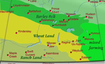
agriculture |
This illustration gives you some idea of the way agriculture tends to be carried out in Saskatchewan. Though grain farming is a major land use in the Southwestern portion of the province the yields are much lower than would be experienced elsewhere and the rolling countryside lends itself much more readily to ranching. Similarly this illustrates a golden area of farmland that tends to be used for grain production in the wheat lands but farmers here also grow Canola and other crops. The Southeastern part of the province is lightly wooded and the farms here are smaller than in other parts of the province and similar in production to Manitoba farms with lots of cattle and other livestock This area has considerable variation in productivity from marginal to very high yielding areas often only miles apart. |
|
|
|
|
barley |
The "barley belt" as we have named it here is the area along what is referred to as Saskatchewan's park land that was once mixed forest and in general receives much more precipitation each year than the rest of the province. Even though it has a shorter growing season the productivity in this area is substantially higher than anywhere else. Though this country can grow barley, it equally can produce wheat, oats and the majority of the provinces Canola production comes from this slice of countryside. In the last two years wheat yields in this part of Saskatchewan have been almost double that of the rest of the province. This area has extremely rich soil with the Northern portion of it consisting mostly of peat. Almost all of Saskatchewan's forestry takes place on the Northern edge of this part of the province. |