
Fay Dumps Record-Breaking Rain; Flood Victims Warned Of Alligator Swimming In Streets
Homeowners Forced To Use Canoes
POSTED: 1:17 pm EDT August 20, 2008
UPDATED: 7:16 am EDT August 21, 2008
MELBOURNE, Fla. -- Homeowners in a Tropical Storm Fay-flooded community were being warned of an alligator swimming in their streets and near homes as record-breaking rain continued to fall Thursday.
Residents on Wickham Road in Melbourne were forced to use canoes to maneuver around their flooded streets.
Several homes were reported to have flooded and some streets near the Kings Hills subdivision had waist-deep water.
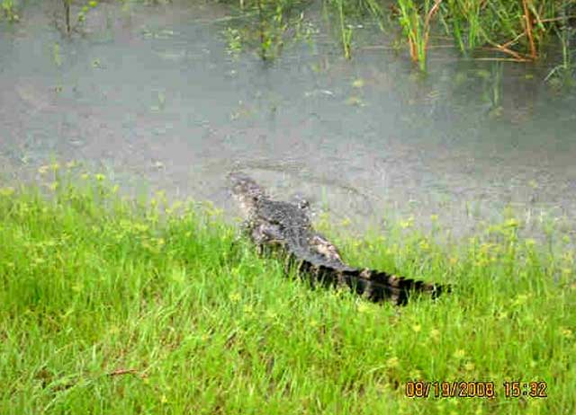
There are also reports of an alligator in the flooded neighborhood streets, which is another thing residents have to worry about, Local 6's Jessica Sanchez reported.
"We have removed alligators, we have removed snakes and we've removed all kinds of wildlife," Brevard EOC Director Bob Lay said. "Our animal services and enforcement officers have been doing this all over the county for the last three days."
Some Local 6 viewers sent images of alligators in their neighborhoods -- including one gator captured by animal services.
The National Guard has been called to Melbourne to help with voluntary evacuations.
Record-Breaking Rain Reported
Meanwhile, the city of Melbourne shattered a 50-year-old rainfall record after the system dumped hours of rain in the area.
The city received more than 11 inches of rain in a 24-hour period.
"Some folks (in Palm Bay) have more than 1 foot of water already in their back yards, causing flooding," Sorrells said. "Other areas around Central Florida are wondering what the big deal is."
Fay Stalls
The National Hurricane Center's projected path of movement for Tropical Storm Fay now includes a fourth Florida landfall as it continues to dump "historic" amounts of rain on parts of Central Florida.
"Fay will be with us for the next 48 hours at least," Wilson said. "Thankfully, by Friday morning, it should be (located) just to the north of Ocala and on its way out of Florida. But if (Fay) does take this path into the Gulf of Mexico it would (make) its fourth landfall into Florida."
Fay's third landfall Thursday will again deliver heavy rain and high winds to Central Florida counties, Local 6 meteorologist Tom Sorrells said.
Marion County can expect 30 to 40 mph winds with some thunderstorms and heavy rain.
Flagler County could also see winds up to 38 mph with higher gusts on the latest path of projected movement. The highest wind speeds will come between 6 a.m. and noon.
Sanford had wind gusts approaching 40 mph early Thursday.
The National Hurricane Center's path of projected movement showed the storm no longer threatening to intensify into a hurricane Thursday as initially predicted. However, more record-breaking rain is possible.
"The good news with this is that the threat of tornadoes is almost nil in our viewing area," Local 6 meteorologist Eric Wilson said.
Fay should deliver rain into Central Florida until at least Friday.
Tornado Damages 54 Homes
Also, at least three people were injured and 54 homes damaged when a Fay-spawned tornado touched down in Brevard County Tuesday.
Barefoot Bay resident Frank Amoretti reported seeing a tornado touch down in the vicinity of Brown Road and Puffin Drive west of U.S. 1 in Brevard County Tuesday afternoon.
"I saw the swirling and stuff and there was a lot of debris and everything," resident Frank Amoretti said. "As quick as it came in, it looked like it went right back up. It looks like part of a house or part of a roof and a couple of carports and a lot of aluminum and insulation and construction barricades from Mico Road."
Brevard County reported 50 structures were damaged by the tornado and nine of them were completely destroyed.
The tornado was confirmed by the National Weather Service to have touched down about an hour after it was reported, Wilson said.
The National Weather Service had issued a tornado warning for Brevard and Osceola counties before the damage reports.
Watch Local 6 News for more on this story.