FTLComm - Tisdale - June 27, 1998
Developing throughout Saskatchewan on Thursday were a number of potentially dangerous
storm cells. The image on the right shows an immature version of the typical thundercloud
but demonstrates the dynamics within this mini weather system. Because the temperatures
were relatively high air close the ground heats up rapidly and takes up more space,
it is lighter and therefore it rushes upward. This same air, because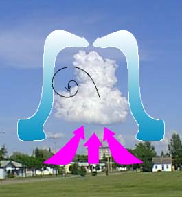 of its temperature can carry a
considerable amount of water vapour. The rising warm air climbs to the level where
the temperature is at dew point and condensation begins to take place as the water
vapour becomes visible steam. That point forms the sharply defined base of the towering
cumulous cloud. But the air still is warm and continues to rush upward. The speed
of this rise can be about 2,000 feet a minute so that in three minutes what was on
the surface could be a nautical mile high. The purple on the image at right indicates
this rising wet air.
of its temperature can carry a
considerable amount of water vapour. The rising warm air climbs to the level where
the temperature is at dew point and condensation begins to take place as the water
vapour becomes visible steam. That point forms the sharply defined base of the towering
cumulous cloud. But the air still is warm and continues to rush upward. The speed
of this rise can be about 2,000 feet a minute so that in three minutes what was on
the surface could be a nautical mile high. The purple on the image at right indicates
this rising wet air.
As the air rises in the column it cools and the water vapour condenses and forms
water droplets which are carried upward, as the cloud grows in size the amount of
suspended water increases to the point where the rising warm air can not longer hold
it aloft and it begins to fall in the form of precipitations. But, really large clouds
of this type have huge energy potential and carry the water so that it freezes and
begins to descent where it collects more water, in turn rises freezing another layer
of water then falls and so on forming hail. At some point the cloud can no longer
hold the material and it falls to the ground.
From the top of the cloud and running down its sides is the air that had rushed upward
is now cooled and falls downward with the same speeds with which it rose, blue arrows,
over 2,000 feet a minute. Air coming up the outside of the cloud can be caught in
the zone between the rising and falling columns of air and develop into a rotary
cloud which is demonstrated here with the black line. This little cloud actually
has small rotary clouds developing right where the point of the arrow meets the cloud.
In a fully grown big version of this cloud
![]()
![]()
![]()