|
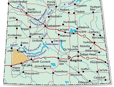
At the end of the last ice age not all of Saskatchewan had been covered as the Cypress
Hills south of Maple Creek were not covered, but the rest of the province
was under a massive glacial cover. As the temperatures warmed the ice began to retreat
to the north with rivers forming and flowing on and under the ice. It appears as
though for some time the bottom end of the ice cover was somewhere along what is
now the TransCanada highway and the melting ice water carried with it sand,
gravel and loam which was deposited in a huge terminal moraine indicated by the sand
colour on this map.
A glacial moraine produces a unique terrain soil and debris is dumped on the surface
producing kettle lakes and ponds, random hills and valleys occur but there is no
drainage system, no streams and rivers so that rain and snow simple fall on the area
and settle into the groundwater. Areas like this will have highly mineralised water
deposits since dissolvable salts will leach from the soil and have not place to go
but build up in the water table. The material in this huge moraine area consisted
of a mixture of things as we saw clays, sand and in some areas north of Tompkins,
fields strewn with rocks and boulders
A controversy has grown up around this part of the province as conservationists and
some environmentalists are alarmed at the amount of oil field activity in the area.
This month the province has decided to issue further permits for increased gas field
development and many have warned that
this will endanger the already fragile environment. When I set to work to post Edwin Wallace's concerns
about this area I discovered few pictures of the area online and borrowed a picture
from the St. Angela's Academy web site from nearby Prelate. (While we were at the dune site a class
from the Academy arrived to explore the dunes.) So on Wednesday afternoon
we drove from Swift Current out to Tompkins (west of Gull Lake)
then went ten kilometres west on highway one and turned north into the vast area
of range land and rolling drumlin hills that form the Great Sand Hills
The very first thing we discovered was that the Great Sand Hills, though from
a road map appear to be devoid of roads and people are anything but desolate. The
place is teaming with life, huge cattle spreads, we barely made a mile without having
to stop to photograph yet another unusual bird. raptors, songbirds, water fowl and
pronghorn antelope, though it is geographically classed as a desert because of its
low amount of rainfall it is definitely not deserted. The soil is held in place by
a fragile cover of prairie grasses and an assortment of other shrubs. Their root
system is the net that covers the dunes which are everywhere and prevents the place
from looking like Saudi Arabia.
The slide show tour (right, requires a recent version of QuickTime to be seen)
is a review of the pictures we captured as we made our way north then west across
the Sand Hills to Fox Valley mid way between Maple Creek and Leader.
Though we kept our speed down we punctured a tire on a bullet shaped stone and limped
into Fox Valley on the donut which itself was low in pressure. From Fox
Valley we went north to Liebenthal, three quarters the way from Maple
Creek to Leader and we headed east fifteen kilometres then followed a
road made for folks like us to take us to the active dunes.
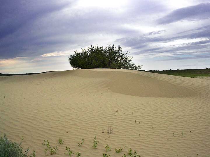
The dunes are well beyond descriptive words like huge and they are alive shifting
with the wind so that on the lea side they are almost an illusion as you can sink
you hand into the almost weightless material past your wrist without resistance while
on the top and the windward side moisture from the very light rain produced a crust
that easily supported my weight. On the windward side it was clear to see how devastating
their movement is upon life as they swallow plants exposing their roots in tangles.
We followed a trail from the parking lot toward the dunes and the trail is much deeper
than the surrounding surface then we took a cow path up a hillside to overlook the
dunes and it too was recessed. Any place where the root structure is exposed the
wind digs out the material and sand piles up on the edges. The road into the area
appears to be carved out of the surrounding landscape but it is just the opposite
as the edge of the road becomes a drift collection and the sand on the road way is
gradually eroded.
The most dramatic scene was atop the hill looking toward the dunes from which I produced
the QuickTime VR panorama
seen at the bottom of this page. The very crest of the hill is in fact a crater.
The surface area at some time had been broken open and the wind swirled away a substantial
hole about the size of a house, which indeed will continue to grow. Clearly, every
footstep can produce a potential erosion area and in the slide show you will see
some images of the sparse growth network on the ground which is holding the soil
in place.
Petroleum exploration and development has been a part
of this part of Saskatchewan for decades and we saw evidence of pipeline after pipeline
from well head to compression batteries. We only saw one flare, it was at a newly
developed site where work was in progress. The production companies now compress
all of the material that might have been flared in the past and this product is transported
for processing. What is most important to understand is that the gas field in production
between Gull Lake and Sceptre is a sweet gas field. What this means
is that the natural gas in this field does not contain the deadly hydrogen sulfide
(sour gas, the smell of rotten eggs). This explains the absence of flares and added
safety in that a well head leak will not dump toxic poisonous gas into the atmosphere.
I could see nothing that posed a threat to the area from addition oil and gas development.
The primary threat to the ecology is the vast herds of cattle on the range and as
long as there is rain and the growth on the surface is supported the cattle will
not produce excessive erosion. I interviewed several folks along the way, as I said
the place is far from empty.
There are more cattle on the ranches than usual because of the closure of the US
border to Canadian cattle on the hoof. Most farmers retained the older cows that
would have been sold last summer and they just can not hang on to them and the ones
that are due to be marketed this year. One rancher explained that seven year old
cattle were selling at Maple Creek last week for $120 a cow. That certainly
makes one wonder what the heck is going on with a cow selling for what adds up to
16¢ a pound with supermarket prices of all beef products well over a dollar.
The ranchers are careful with the environment and many, because of the BSE
crisis are working part time in the gas and oil industry. The ones I talked to felt
that continued development of the gas field is vital to Saskatchewan's interest and
there was no threat to the environment.
The old days of the wild wreck and ruin methods of drilling and production are long
gone. The production companies are painfully aware of the need to be environmentally
friendly if they want politicians and the public to permit their industry to develop.
They are very conscious of the need to restore the surface after development and
take care to maintain their sites with grounds people who seed grass and keep the
weeds in check.
It was in Fox Valley that the impact of the gas field was to be noticed. We
had to have our tire repaired and the only other customers at the tire shop were
oil field workers. Fox Valley was once a very busy community but like all
Saskatchewan rural villages it has suffered from the depopulation of rural areas
and the only food store in the town is a convenience store, albeit a very well stocked
convenience store. A shopper told me that everything she needed was available at
the store with the exception of fresh meat, but as we were talking four or five gas
field pick up trucks rolled up to the store and their drivers hopped out to get necessities.
The economy of Fox Valley and most likely all of the towns surrounding the Great
Sand Hills depends upon the petroleum development and production.
With our own need for fuel and the value of production going to provincial and federal
government the Great Sand Hills is one of Saskatchewan's most valued assets. There
is no doubt that conservation and careful planning will be needed to maintain the
ecology but there is no reason that cattle, livestock and petroleum can all peacefully
coexist.
However, it might be a good idea, if conservationists are truly concerned about the
plants and animals, the dunes and the fragile area on the top west corner of the
Sand Hills, that they should set the wheels in motion to produce a park to
preserve some of this natural habitat without future development.
|
|
|
|
|
Return to Ensign
- Return to Saskatchewan
News
|
| |
| This page is a story posted on Ensign and/or Saskatchewan
News, both of which are daily web sites offering a variety of material from scenic
images, political commentary, information and news. These publications are the work
of Faster Than Light Communications . If you would like to comment on this story or you wish to contact
the editor of these sites please send us e-mail. |
| |
|
Editor : Timothy W. Shire
Faster Than Light Communication
Box 1776, Tisdale, Saskatchewan, Canada, S0E 1T0
306 873 2004
|
|